

By: Ralf Ellspermann
25-Year, Multi-Awarded BPO Veteran
Published: 17 March 2026
Updated: March 16, 2026
TL;DR: The Key Takeaway
Satellite imagery annotation outsourcing to India has transcended traditional data labeling, becoming a strategic imperative for organizations seeking to extract maximum value from their geospatial data. The nation’s unique combination of a massive STEM talent pool, advanced IT infrastructure, and deep expertise in AI/ML is empowering companies to achieve superior model performance and unlock new frontiers in geospatial intelligence.
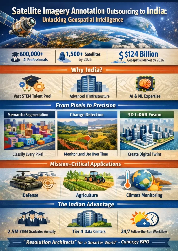
Outsourcing satellite imagery annotation to India provides the high-fidelity ground truth required for planetary-scale AI. As of 2026, the global geospatial analytics market is projected to reach $124 billion, with India serving as the primary hub for “Intelligence Arbitrage.” By leveraging a workforce that includes over 600,000 AI professionals and graduates from top-tier institutions like the IITs, Indian providers deliver specialized tiers of annotation—from semantic segmentation for urban planning to 3D LiDAR fusion for digital twins—ensuring 99% label accuracy for mission-critical applications in defense, agriculture, and climate monitoring.
Executive Briefing
- The Geospatial Deluge: In 2026, over 1,500 active Earth observation satellites generate petabytes of daily data, shifting the industry bottleneck from “data acquisition” to “high-fidelity interpretation.”
- Intelligence Arbitrage: The value proposition has shifted from cost-savings to accessing a STEM-heavy workforce capable of resolving complex spectral signatures and 4D temporal changes.
- Research Powerhouse: India’s $1.24 billion IndiaAI Mission has democratized high-end GPU access, allowing Indian BPOs to use AI-assisted tools to pre-label 80% of imagery, leaving high-complexity “edge cases” for human experts.
- Strategic Connector: Cynergy BPO vets the top 1% of Indian geospatial teams, ensuring compliance with ISO 27001 and the Digital Personal Data Protection (DPDP) Act 2026.
From Pixels to Precision: The Geospatial Imperative
Satellite imagery is no longer just about “looking at pictures.” In 2026, it is about automated feature extraction. To train an AI to identify crop health, track illegal mining, or assess post-disaster damage, the model must first “learn” from millions of meticulously labeled pixels.
Modern geospatial AI requires more than bounding boxes. It demands Semantic Segmentation (classifying every pixel), Instance Segmentation (distinguishing between individual objects in a cluster), and Temporal Change Detection (identifying subtle variations in land use over years).
The Indian Advantage: Talent and Technology
India’s emergence as the “Geospatial Command Center” of the world is driven by a unique 2026 ecosystem:
- Talent Density: With 2.5 million annual STEM graduates, India provides a scalable workforce that understands the remote sensing physics behind the data.
- Infrastructure: High-speed fiber backbones and Tier 4 data centers enable the seamless transfer of massive COGS (Cloud Optimized GeoTIFFs) and SAR (Synthetic Aperture Radar) datasets.
- Follow-the-Sun Speed: US-based firms can task a dataset at 5 PM EST; the Indian team processes it during the US night, delivering refined results by 9 AM EST the next day.
Geospatial Annotation Complexity Matrix
Choosing the right level of talent for the specific task is critical for maximizing ROI and model safety.
| Annotation Tier | Key Tasks & Deliverables | Required Skillset | Strategic Impact |
| Tier 1: Foundational | Bounding Boxes, Point Annotation | Attention to detail, basic GIS | Large-scale object detection (e.g., ship counting) |
| Tier 2: Advanced | Semantic & Instance Segmentation | Analytical skills, Computer Vision knowledge | Precise boundary delineation for urban tax mapping |
| Tier 3: Contextual | Change & Anomaly Detection | Domain expertise (Agri/Environ) | Proactive risk mitigation (e.g., deforestation alerts) |
| Tier 4: Expert | 3D & Multi-Modal Fusion | LiDAR/SAR data structures | Creation of Digital Twins for Smart Cities |
Satellite Imagery Annotation Service Tiers
Cynergy BPO aligns your project requirements with the appropriate service level to ensure cost-efficiency and technical accuracy.
- Standard Service: High-volume labeling of common features like buildings, roads, and water bodies. Ideal for general land-cover mapping.
- Premium Service: Tasks requiring domain-specific knowledge, such as identifying specific crop types or assessing infrastructure integrity.
- Enterprise Service: Fully managed, dedicated teams for mission-critical applications like autonomous drone navigation or national security intelligence.
“In 2026, we are no longer just ‘labeling pixels.’ We are providing the cognitive engine for global resilience. Indian specialists are now ‘Resolution Architects’ who interpret complex spectral data to help models predict everything from famine to urban heat islands.” — John Maczynski, CEO of Cynergy BPO
Expert FAQs
Q1: How does India handle the security of sensitive geospatial data?
Top Indian providers utilize Zero-Trust Architectures and are fully compliant with the DPDP Act 2026. Data is often processed in “Secure Data Clean Rooms” where external storage and internet access are physically and digitally blocked, ensuring that proprietary or sensitive imagery never leaves the secure environment.
Q2: Can Indian teams work with SAR (Synthetic Aperture Radar) data?
Yes. SAR data interpretation is a high-level skill, as it doesn’t “look” like a standard photo. Indian engineers from the IITs are trained in signal processing, allowing them to accurately annotate SAR imagery for applications like night-time monitoring or cloud-penetrating surveillance.
Q3: What is “Intelligence Arbitrage” in geospatial terms?
It is the move from hiring “low-cost taggers” to hiring “subject matter experts.” In 2026, you outsource to India to access data scientists who can identify SOTIF (Safety of the Intended Functionality) failures in your models—such as an AI misidentifying a flooded area as a shadow—and correcting the training data accordingly.
Q4: How does the IndiaAI Mission reduce my costs?
The mission provides subsidized access to high-end GPU clusters for local providers. This allows them to run advanced AI-assisted labeling tools internally, which speeds up the annotation process by 3x to 5x without the client having to pay for expensive third-party compute licenses.
Share This
Unlock cost-efficient growth with expert BPO guidance!
Partner with Cynergy BPO to connect with top outsourcing providers.
Streamline operations, cut costs, and scale your business with confidence.
Book a Free Call
Ralf Ellspermann - CSO
Author
Ralf Ellspermann is the Chief Strategy Officer (CSO) of Cynergy BPO and a globally recognized authority in business process and contact center outsourcing. With more than 25 years of experience advising enterprises and SMEs, he provides strategic guidance on vendor selection, CX optimization, and scalable outsourcing strategies across global markets. His expertise spans fintech, ecommerce and retail, healthcare, insurance, travel and hospitality, and technology (AI & SaaS) outsourcing.
A frequent speaker at leading industry conferences, Ralf is also a published contributor to The Times of India and CustomerThink, where he shares insights on outsourcing strategy, customer experience, and digital transformation.