

By: Ralf Ellspermann
25-Year, Multi-Awarded BPO Veteran
Published: 23 March 2026
Updated: March 17, 2026
TL;DR: The Key Takeaway
Outsourcing geospatial data annotation to India offers a strategic advantage for businesses seeking to transform raw satellite and aerial imagery into high-quality, AI-ready datasets. The nation’s mature IT-BPM sector, combined with its vast pool of skilled professionals, ensures the precise labeling and enrichment of location-based data, driving innovation in everything from urban planning to precision agriculture.
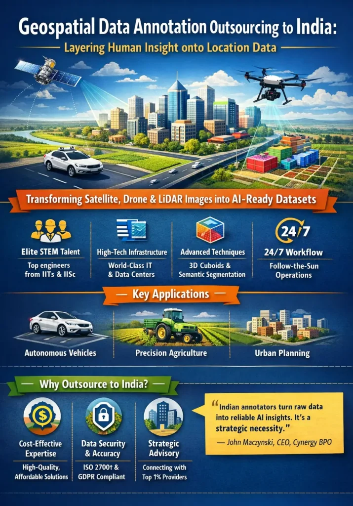
Geospatial data annotation outsourcing in India provides the high-precision human intelligence necessary to transform raw satellite, drone, and LiDAR data into structured training sets. By leveraging an elite STEM-educated workforce, Indian BPO providers implement complex techniques like 3D cuboid annotation and semantic segmentation, enabling the development of robust AI models for autonomous navigation, precision agriculture, and urban planning in the 2026 digital economy.
Executive Briefing
- Elite STEM Ecosystem: Access to a massive pool of engineers from the IITs and IISc, providing the technical rigor required for complex geographic labeling.
- Industrial-Scale Infrastructure: World-class IT frameworks capable of processing the high-bandwidth imagery and massive point clouds inherent in geospatial analysis.
- Research-Driven Insights: Deep expertise in AI/ML allows Indian teams to use agentic tools to pre-label and validate data, increasing speed without sacrificing precision.
- Operational Synergy: A 24/7 “follow-the-sun” workflow enabled by the India-US time zone difference, combined with near-native English proficiency.
- Strategic Advisory: Cynergy BPO connects innovators with the top 1% of specialized geospatial units, ensuring data integrity and model reliability.
Executive Summary
The strategic outsourcing of geospatial data annotation to India has become a cornerstone for global organizations navigating the location-intelligence boom. As sectors ranging from urban planning to precision agriculture rely on AI to interpret the physical world, the demand for meticulously labeled location data has reached a critical threshold. This South Asian hub offers a powerful synthesis of human capital and technological maturity. By partnering with specialized Indian providers, companies can transform raw pixels and point clouds into high-fidelity training data. This is not merely an exercise in labeling; it is the strategic layering of human context onto digital maps. The Indian IT-BPM sector provides the governance and security necessary to unlock the full potential of geospatial intelligence, ensuring that AI models are not just functional, but contextually aware and safe for real-world deployment.
The Bedrock of Modern AI: Why High-Quality Geospatial Data is Non-Negotiable
In 2026, raw data is abundant, but actionable intelligence is rare. For machine learning to succeed, data must be “breathed into” through annotation—the process of adding labels that tell an algorithm what it is looking at. For geospatial AI, this is exceptionally difficult. A model identifying land use must know the difference between a residential rooftop and a commercial warehouse at sub-meter resolution.
Engaging with India’s talent corridor provides a distinct advantage in this “Intelligence Arbitrage.” Indian engineers are adept at high-level techniques like semantic segmentation, where every pixel in a satellite image is classified, and 3D cuboid annotation, essential for teaching autonomous vehicles the orientation of physical obstacles. This maturity translates into a seamless experience characterized by robust data security and a commitment to “Alignment Fidelity”—ensuring the AI’s perception matches human reality.
“The level of detail that Indian data annotators bring to the table is what separates a functional AI model from a truly transformative one. It is no longer a cost-saving measure; it is a strategic necessity.” — John Maczynski, CEO, Cynergy BPO
From Raw Pixels to Actionable Intelligence: The Annotation Process
The transformation process is multi-staged and demands extreme precision. It moves from raw collection—satellites, drones, and terrestrial LiDAR—into a specialized human-in-the-loop (HITL) workflow. Skilled annotators use advanced software to apply labels based on specific project guidelines, such as mapping irrigation systems for agriculture or building footprints for urban densification.
Core Annotation Techniques
| Technique | Description | Primary Use Case |
| Semantic Segmentation | Assigning a class label to every pixel. | Land use, environmental monitoring. |
| Polygonal Annotation | Tracing the exact outlines of complex shapes. | Building footprints, road networks. |
| 3D Cuboid Annotation | Enclosing objects in 3D boxes for orientation. | Autonomous driving, robotics. |
| Point Annotation | Marking specific coordinate points. | Asset tracking, landmarking. |
Throughout this process, Agentic Governance is applied. This involves multi-layered reviews where senior annotators and automated scripts validate accuracy, ensuring that the final “AI-ready” dataset is flawless.
The Strategic Imperative of Intelligence Arbitrage
In the 2026 AI race, speed is vital, but quality is the final arbiter of success. Intelligence arbitrage in the Indian context means accessing a deeper pool of domain-specific knowledge. A team in Bangalore with a background in urban planning is naturally better at identifying the subtle visual differences between residential and commercial zones than a generalist workforce.
This domain expertise allows Indian BPO providers to act as strategic partners. They don’t just execute tasks; they offer recommendations on how to optimize the annotation schema for better model performance. This “Managed Service” approach ensures that the return on investment (ROI) is measured in model reliability and faster deployment cycles, not just lower hourly rates.
Agentic Governance: Ensuring Quality and Security
Handling high-resolution satellite imagery and proprietary LiDAR scans requires uncompromising security. Leading Indian providers operate under “Agentic Governance”—a proactive management style that prioritizes trust and transparency.
- Security: Adherence to ISO 27001 and GDPR standards, with secure, air-gapped data centers and encrypted pipelines.
- Quality Management: Continuous training programs and the use of AI-assisted tools to pre-annotate data, which humans then refine for 99.9% accuracy.
- Communication: Direct channels between US engineering teams and Indian project managers ensure that guidelines are interpreted correctly and updated in real-time.
Expert FAQs
Why is India preferred for LiDAR and 3D annotation?
India’s large pool of computer science and civil engineering graduates provides the spatial reasoning skills necessary to interpret 3D point clouds, which are significantly more complex than 2D images.
How is data privacy maintained for sensitive imagery?
Providers use secure virtual desktop infrastructures (VDI) and multi-factor authentication. Data often remains on the client’s cloud, with annotators only accessing it through secure, read-only portals.
What is the impact of AI-assisted annotation in India?
Indian firms are pioneers in using “AI-to-train-AI.” They use automated models to provide initial “coarse” labels, which human experts then “fine-tune,” resulting in a 40% increase in speed while maintaining human-level precision.
Can Indian teams handle niche geospatial domains like maritime or space?
Yes. Due to the maturity of the ecosystem, specialized boutique firms exist that focus exclusively on maritime traffic monitoring, forestry, or deep-space imagery.
Share This
Unlock cost-efficient growth with expert BPO guidance!
Partner with Cynergy BPO to connect with top outsourcing providers.
Streamline operations, cut costs, and scale your business with confidence.
Book a Free Call
Ralf Ellspermann - CSO
Author
Ralf Ellspermann is the Chief Strategy Officer (CSO) of Cynergy BPO and a globally recognized authority in business process and contact center outsourcing. With more than 25 years of experience advising enterprises and SMEs, he provides strategic guidance on vendor selection, CX optimization, and scalable outsourcing strategies across global markets. His expertise spans fintech, ecommerce and retail, healthcare, insurance, travel and hospitality, and technology (AI & SaaS) outsourcing.
A frequent speaker at leading industry conferences, Ralf is also a published contributor to The Times of India and CustomerThink, where he shares insights on outsourcing strategy, customer experience, and digital transformation.