

By: Ralf Ellspermann
25-Year, Multi-Awarded BPO Veteran
Published: 2 April 2026
Updated: March 23, 2026
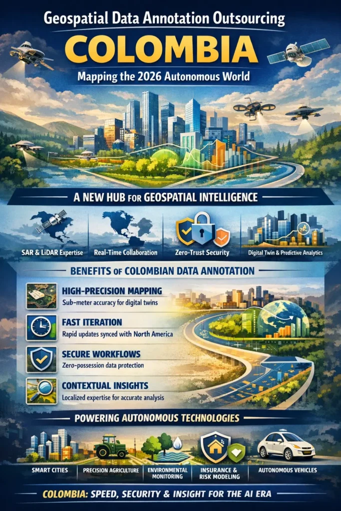
Colombia has become a nearshore leader in geospatial data annotation by delivering high-precision, real-time spatial intelligence for AI systems. Its combination of multispectral expertise, synchronous collaboration with North America, and zero-trust security frameworks enables enterprises to build accurate digital twins, accelerate decision-making, and scale autonomous technologies with confidence.
- Colombia is emerging as a strategic hub for high-fidelity geospatial annotation in the AI economy
- Specialized talent delivers multispectral, SAR, and LiDAR-based intelligence
- Real-time collaboration with North America enables faster model iteration and validation
- Zero-possession security ensures compliance with strict global data regulations
- Advanced workflows support digital twins, autonomous systems, and predictive analytics
- Enterprises report measurable gains in model accuracy and operational responsiveness
A New Center of Gravity in the Spatial Economy
The global shift toward autonomous systems has transformed geospatial data from static reference material into a dynamic, continuously updated intelligence layer. In this environment, Colombia has positioned itself as a high-value nearshore destination where spatial data is not merely processed—but engineered into actionable insight.
Through curated partnerships facilitated by Cynergy BPO, enterprises gain access to highly trained geospatial analysts capable of interpreting satellite, drone, and radar imagery at extraordinary levels of precision. These specialists operate at the intersection of geographic science and machine learning, producing structured datasets that power everything from smart cities to environmental risk modeling.
What distinguishes Colombia is not just cost efficiency or proximity. It is the depth of technical capability combined with real-time collaboration—an increasingly critical factor in industries where delays can translate into operational or financial risk.
From Static Maps to Living Digital Twins
The concept of mapping has evolved. In 2026, organizations no longer rely on fixed geospatial snapshots. Instead, they require continuously updated representations of the physical world—digital twins that reflect change as it happens.
Colombian annotation teams are at the forefront of this transformation. Their work extends beyond outlining physical structures; they define relationships, attributes, and temporal changes within spatial environments. This enables AI systems to distinguish between transient disruptions and permanent infrastructure changes.
A defining strength lies in change detection. Analysts are trained to interpret historical image sequences, enabling models to identify patterns such as urban expansion, deforestation, or infrastructure degradation. This capability is essential for predictive analytics across sectors like insurance, agriculture, and urban planning.
The Nearshore Advantage: Speed Meets Context
Geographic proximity to North America introduces a powerful operational advantage—synchronous execution. When data is captured in real time, it can be processed, validated, and reintegrated into AI systems within hours rather than days.
This alignment allows enterprises to maintain continuous feedback loops between data scientists and annotation teams. Whether responding to wildfire spread, monitoring construction progress, or analyzing logistics networks, speed becomes a decisive factor.
Equally important is contextual accuracy. Colombian teams bring familiarity with Western infrastructure patterns, environmental conditions, and regulatory frameworks. This contextual understanding reduces ambiguity in labeling and enhances the reliability of downstream AI models.
As John Maczynski, CEO of Cynergy BPO, explains: “The competitive edge in 2026 lies in how quickly organizations can transform raw spatial data into usable intelligence. Colombia delivers that speed without compromising precision.”
Table 1: Strategic Benefits of Colombian Geospatial Annotation (2026)
| Advantage | Technical Capability | Business Impact |
| High-Resolution Precision | Semantic segmentation of sub-meter imagery | Enables engineering-grade digital twins |
| Radar & Multispectral Analysis | Interpretation of SAR, thermal, and RGB data | Ensures visibility across all environmental conditions |
| Temporal Intelligence | Tracking changes across time-series datasets | Supports predictive risk modeling |
| Bilingual GIS Expertise | Cross-language data interpretation | Streamlines US–LATAM infrastructure projects |
| Secure Delivery Models | Encrypted, zero-possession workflows | Protects sensitive geospatial assets |
Engineering Spatial Intelligence at Scale
Building robust spatial AI systems requires more than raw data—it demands rigorous validation across every stage of the lifecycle. Colombian providers have developed specialized workflows that manage this complexity from initial image correction to advanced AI verification.
These workflows are designed to ensure that every pixel contributes to reliable predictions. By combining human expertise with AI-assisted validation, Colombian teams achieve high levels of accuracy while maintaining scalability.
Table 2: The 2026 Geospatial Lifecycle in Colombia
| Phase | Technical Contribution | Enterprise Value |
| Image Validation | Geometric correction and quality assurance | Eliminates distortions in training data |
| Feature Segmentation | Detailed labeling of terrain and infrastructure | Enables accurate environmental analysis |
| Metadata Enrichment | Adding contextual attributes to features | Supports advanced analytics and audits |
| 3D Data Verification | Validation of LiDAR and photogrammetry outputs | Powers autonomous navigation systems |
| Boundary Mapping | Defining legal and operational zones | Enhances compliance and asset management |
| Human-AI Validation | Expert review of AI-generated outputs | Ensures safe and reliable automation |
Security and Compliance as Differentiators
Handling geospatial data often involves sensitive information—critical infrastructure layouts, environmental monitoring systems, and even defense-adjacent datasets. Colombian providers address this through zero-trust architectures that prevent data from being stored locally.
Instead, analysts work within secure virtual environments where data is streamed in real time. This “zero-possession” model aligns with stringent global data protection standards while reducing the risk of breaches.
Additionally, government-backed initiatives such as CONPES 4144 have elevated geospatial engineering into a recognized technical discipline. This has resulted in a workforce that combines academic rigor with practical expertise.
Expert FAQs
How do Colombian providers handle large-scale, cloud-native geospatial workflows?
Leading Colombian teams operate directly within client-owned cloud environments such as AWS S3 or Azure Blob Storage. Using secure virtual desktop infrastructure (VDI), analysts access and annotate massive datasets without downloading them—reducing latency, eliminating duplication, and maintaining full data control within enterprise systems.
What quality benchmarks define high-performing geospatial annotation teams?
Top-tier providers are evaluated using metrics such as Intersection over Union (IoU), with leading Colombian firms consistently achieving scores of 0.94 or higher on complex urban and environmental datasets. These benchmarks reflect precise feature extraction, consistent labeling standards, and strong human-in-the-loop validation processes.
Can Colombian teams manage sensitive or regulated geospatial data?
Yes. Most advanced providers operate under zero-possession security models, where data is streamed into secure environments but never stored locally. This approach aligns with global data protection standards and is suitable for handling infrastructure, energy, and defense-adjacent datasets requiring strict confidentiality.
How does nearshore alignment improve geospatial AI outcomes?
Time-zone synchronization with North America enables real-time collaboration between data scientists and annotation teams. This allows for immediate feedback, faster iteration cycles, and rapid integration of updated training data into AI models—significantly improving responsiveness and model performance.
What industries benefit most from geospatial annotation outsourcing to Colombia?
Key sectors include autonomous transportation, smart cities, precision agriculture, environmental monitoring, insurance risk modeling, and utilities. Any industry relying on accurate spatial intelligence and real-time environmental awareness gains measurable advantages from Colombia’s capabilities.
What role does human expertise play alongside AI in geospatial workflows?
Human analysts remain essential for validating complex spatial relationships, interpreting ambiguous features, and auditing AI-generated outputs. Colombian teams specialize in this “agentic verification” layer, ensuring that automated systems operate with high confidence and reduced risk of error.
Share This
Unlock cost-efficient growth with expert BPO guidance!
Partner with Cynergy BPO to connect with top outsourcing providers.
Streamline operations, cut costs, and scale your business with confidence.
Book a Free Call
Ralf Ellspermann - CSO
Author
Ralf Ellspermann is the Chief Strategy Officer (CSO) of Cynergy BPO and a globally recognized authority in business process and contact center outsourcing. With more than 25 years of experience advising enterprises and SMEs, he provides strategic guidance on vendor selection, CX optimization, and scalable outsourcing strategies across global markets. His expertise spans fintech, ecommerce and retail, healthcare, insurance, travel and hospitality, and technology (AI & SaaS) outsourcing.
A frequent speaker at leading industry conferences, Ralf is also a published contributor to The Times of India and CustomerThink, where he shares insights on outsourcing strategy, customer experience, and digital transformation.